1) irregular topography model

起伏地表模型
1.
Comparison of different migration methods based on SEG irregular topography model data.;
基于SEG起伏地表模型数据的偏移方法比较
2) solid relief mode
地形起伏模型
3) relief surface
起伏地表
1.
Analysis of stack velocity based on relief surface;
基于起伏地表的叠加速度分析
2.
Synthetic plane wave migration in relief surface condition and implementation in parallel way;
起伏地表条件下的合成平面波偏移及其并行实现
3.
Simulation and analysis of seismic wavefield on relief surface by 2-D acoustic wave equation;
起伏地表二维声波方程地震波场模拟与分析
4) irregular topography
起伏地表
1.
Review of seismic wave numerical simulation from irregular topography.;
起伏地表条件下地震波数值模拟方法综述
2.
Review of 3-D geologic model building from irregular topography.;
起伏地表三维建模研究进展与前景
3.
Effects of irregular topography and low velocity layer on reflections.;
起伏地表及低降速带对反射波的影响
5) rugged topography
起伏地表
1.
Realization of initial value ray tracing for rugged topography.;
起伏地表下初值射线追踪的实现
2.
Wave equation finite-element modeling including rugged topography and complicated medium;
起伏地表复杂介质波动方程有限元数值模拟方法
3.
A series of problems has arisen from complex geology such as serious static errors due to rugged topography, distorted seismic events, and low S/N seismic data.
简要介绍了山地资料处理和偏移成像的相关技术,主要包括基准面校正技术和起伏地表偏移成像技术。
6) irregular surface
起伏地表
1.
Phase encoding in prestack migration based on irregular surface;
起伏地表条件下的相位编码叠前深度偏移
2.
Synthetic source record residual migration velocity analysis with irregular surface
起伏地表下合成震源记录剩余偏移速度分析
补充资料:AutoCad 教你绘制三爪卡盘模型,借用四视图来建模型
小弟写教程纯粹表达的是建模思路,供初学者参考.任何物体的建摸都需要思路,只有思路多,模型也就水到渠成.ok废话就不说了.建议使用1024X768分辨率
开始
先看下最终效果

第一步,如图所示将窗口分为四个视图

第二步,依次选择每个窗口,在分别输入各自己的视图
第三步,建立ucs重新建立世界坐标体系,捕捉三点来确定各自的ucs如图

第四步,初步大致建立基本模型.可以在主视图建立两个不同的圆,在用ext拉升,在用差集运算.如图:
第五步:关键一步,在此的我思路是.先画出卡爪的基本投影,在把他进行面域,在进行拉升高度分别是10,20,30曾t形状.如图:
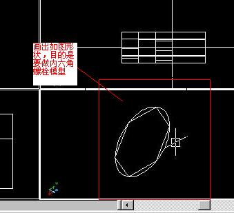
第六步:画出螺栓的初步形状.如图
第七步:利用ext拉升圆,在拉升内六边形.注意拉升六边行时方向与拉升圆的方向是相反的.
之后在利用差集运算
第八步:将所得内螺栓模型分别复制到卡爪上,在利用三个视图调到与卡爪的中心对称.效果如图红色的是螺栓,最后是差集

第九步:阵列
第10步.模型就完成了
来一张利用矢量处理的图片

说明:补充资料仅用于学习参考,请勿用于其它任何用途。
参考词条